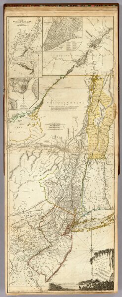
The Provinces of New York, and New Jersey; with part of Pensilvania.
Identifier
0346.020
Collection
pilot2
Description
The Provinces of New York, and New Jersey; with part of Pensilvania, and the Province of Quebec. Drawn by Major Holland, Engraved by Thomas Jefferys, Geographer to His Majesty. Corrected and Improved, from the Original Materials, By Governr. Pownall, Member of Parliament 1776. (with) three inset maps: A Chart Of The Mouth Of Hudson's River, from Sandy Hook to New York; A Plan Of The City Of New York; and Plan Of Amboy, With its Environs, from an Actual Survey. London. Printed for Robt Sayer & John Bennett ... 17 Augt. 1776.