David Rumsey
ArcGIS, QGIS or web apps can simply use this map with web map services. WMTS, TileJSON or XYZ tiles are provided for quick access to processed maps.
Sign in to get links.
Sign in to download GeoTIFF.
Overlay & compare
iiif viewer, iiif info json
Website
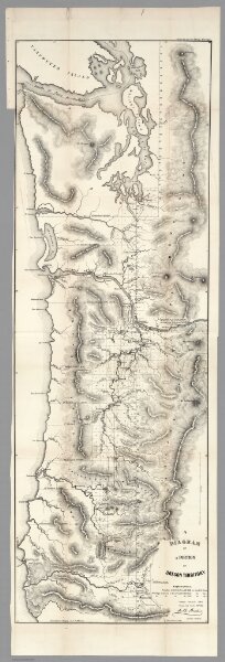
Diagram of a Portion of Oregon Territory, 1852
1077.009
pilot2
A Diagram of a Portion of Oregon Territory. Surveyor General's Office, Oregon City, October 21st, 1852. Surveyor General, J B Preston. Lith. by A. Hoen & Co. Balto.
1852
U.S. General Land Office
A. Hoen
41 × 122 cm
1 : 633600